
|
An Intriguing History
Bandy Field and the surrounding area has a very interesting history. It forms the highest geographical point in all of Richmond and serves as a watershed to two rivers. The water to the east flows into the Chicahominy River, to the west into the James River. Though difficult to find precise information about the eighteen acres constituting Bandy Field, the history of this area reaches back into colonial times. Two old roads
Even though it seems impossible to find precise information about the eighteen acres constituting Bandy Field, we know that the history of this area reaches back into colonial times. The Field is located between two roads already known to the colonists and almost surely to the Indians. The two roads are Three Chopt and Horsepen Roads. Three Chopt Road, also named “Three Notched Trail,” formed the connection between the James River Estates and Charlottesville and was marked by three axe marks along the way. Horses were kept in a pen just north of Three Chopt Road with a gentle brook flowing through it. The path leading to the pen was named Horsepen Road and the brook Horsepen Brook. 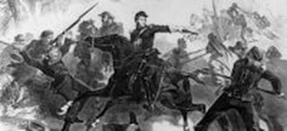 The Dahlgren-Kilpatrick raid on Richmond The Dahlgren-Kilpatrick raid on Richmond
The Civil War and Dahlgren's Raid
During the Civil War, earthworks were constructed in the southwest corner of the Field. In all likelihood they were dug by slaves, according to the book, History of Henrico County, by Louis H. Manarin and Clifford Dowdey (1984). At that time the Field was part of Henrico County. The authors write: “Henricoans had escaped the war for a year and a half…[but in March of l864] a Federal cavalry column under General Judson Kilpatrick had slipped around the right flank of Lee’s army, posted on the Rapidan River and was heading towards Richmond. The object of Kilpatrick’s cavalry raid was to free the Federal prisoners in Richmond and to set fire to the City.” Colonel Ulric Dahlgren was ordered to move with 500 men by way of Goochland Courthouse and across the James River to attack the City from the South. Dahlgren sent a detachment of 100 men under Captain John Mitchell down the north bank of the James with orders to advance as far as Westham Creek and await developments on the other side of the river. Because of the rain and high water, Dahlgren could not cross the river and met up again with Mitchell’s troops in Short Pump. Dahlgren then moved down Three Chopt Road toward Westham Plank Road (River Road) in cold and drizzly weather. The Federal troops met some resistance from home guard and militia forces from Richmond, but they continued their march. At night they were caught by surprise by concentrated fire and retreated. Whether any of this firepower came from the earthworks at Bandy Field we don’t know, but we can assume that Southern troops were stationed there. At that time and at least till l931 Bandy Road was referred to as Battery Road, which points to the importance of the earthworks. Dahlgren was separated with 100 men from the main force and killed a few days later. The majority of Dahlgren’s troops, now under the command of Captain Mitchell, rejoined the main Union force under General Kilpatrick, and Richmond was spared from further attacks for at least a few months. 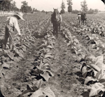
Green's farm
Probably before the Civil War and certainly thereafter, farms were located on Bandy Field. In the 1840s Benjamin W. Green put together a farm of almost 500 acres with the main house located at 6510 Three Chopt Road which has been preserved. On the north side of Three Chopt, the Green farm extended east beyond Patterson Avenue to Horsepen Road. On the Bandy Field side of Three Chopt, it ended at Boatwright Drive and extended to the University of Richmond lake. It is possible that another farm was located on Bandy Field at that time. 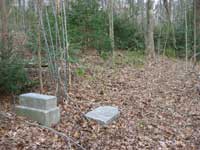
The Council of Ham and the Sons of Ham Cemetery
After the Civil War there were a number of farms on Bandy Field, and it is particularly interesting that sources suggest that freed blacks occupied these farms. They usually built log cabins and owned a horse, a cow, chickens and pigs. They belonged to a community, called Council of Ham. According to Henrico County records, a one-acre plot was sold to the Sons of Ham in 1873. It was used for building a meeting hall and putting in place a cemetery. The meeting hall no longer exists, but the remnants of the cemetery can still be seen. It is located on the part of Bandy Road that is closed to traffic at the top of the steep incline at the South western corner of the Field, just beyond its limits. The history behind the cemetery plot tells us a lot about black organizations after the Civil War. Certain fraternal orders had been formed by slaves even before the Civil War, but afterwards two personalities stand out in the formation of black insurance and fraternal societies: Maggie Walker and William Washington Browne. Browne served “for almost seventeen years as the innovative head of the Grand Fountain of the United Order of True Reformers,” a fraternal society that W.E.B. DuBois characterized as “probably the most remarkable Negro organization in the country” (David Fahey, The Black Lodge and White America, Wright State University Press, l994). Browne also founded an “old folks’ home” on the Westham farm where he had bought 634 acres with money probably collected from members of the fraternal order. A community with the name of Brownesville was established there and 1-4 acre plots were given to small farmers. 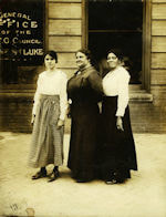 Maggie Walker and The Order of St. Luke Maggie Walker and The Order of St. Luke
Maggie Walker and the Independent Order of St. Luke
While Browne’s enterprise is very interesting, it is only located in the vicinity of Bandy Field. Another insurance company and fraternal order had an immediate connection to Bandy Field: the Independent Order of St. Luke, founded by the remarkable entrepreneur, Maggie Walker, in 1867 as a fraternal benefit association which offered mortuary insurance to members of the association. The national or governing body was known as the Grand Council (also Right Worthy Council), and member groups were referred to as Subordinate Councils. Each subordinate Council adopted a unique name, and as the number of Subordinate Councils increased, they were assigned numbers by the Great Council. Later, members were offered accident and sickness policies. Members paid monthly premiums, a portion of which was retained by the Subordinate Council, a portion went to support the Grand Council, and the rest went into the Trust Fund to pay benefits. The Bradford family
One of the Subordinate Councils of the Order of St. Luke was Ham’s Council. The Order of the Sons and Daughters of Ham later became extinct, as did the Order of St. Luke. Of particular interest is the Bradford family. According to Henrico County deeds, Moses Bradford paid $175 for a five acre plot on Bandy Field in 1873, the same year in which the Sons of Ham purchased their lot. Since according to the l880 census he was born in 1830, it is likely that he was a freed slave. A brother of his or a son from a first marriage, David Bradford bought also a five acre lot in 1881. What makes the life of the Bradford family so interesting is the fact that his son, Moses Bradford, Jr., served in the Spanish-American War of l898. Because of the records kept by the Federal Government on its veterans, we know that he was born in1869. He seems to have been literate, since he signed his name neatly on the enlistment papers. We know from other sources that there was a one-room school, named after Green, which was located on Three Chopt Road. It is possible that Bradford attended this school. He served in Cuba where he suffered a heat stroke in 1898. He was eventually judged unfit for duty by a medical board due to constant headaches. He died in l936. A relative requested a military tombstone which is still standing in the overgrown cemetery, long after the small black farms were abandoned. Altogether there are definitely fifteen gravesites on the cemetery, maybe even more. The last known burial there took place as late as 1945. Besides the extended Bradford family, other black families lived on Bandy Field. A l931 plat for a Virginia Power Company easement lists at least six families, among them names of families that still live in the vicinity of Bandy Field. Among those is Grace Truman. Her descendant owns a refuse business, and the Truman refuse truck can be seen weekly in the neighborhood. It would be very interesting to look into when and why the inhabitants moved away. For more information about the cemetery and the Council of Ham, see “The African-American Community at Bandy Field,” unpublished manuscript, 2006, by Selden Richardson, a member of the Friends of Bandy Field and the President of The Alliance to Conserve Old Richmond Neighborhoods. Other farms
Besides small black farms, there seem to have been some substantial white farms on or near Bandy Field. Records show that a large farm belonged to the Browning family as early as 1893. Mrs. Helen Wren remembered that in the 1930s the Browning farm house stood at the corner of Patterson and Three Chopt, where the Exxon Station is located now. It seems that the Browning farm extended to the present Village Shopping Center and the Northern part of Bandy Field. A member of the Browning family told Mrs. Wren that her brothers used to roll the watermelons down to the creek in order to keep them cool. We heard from a granddaughter of Gilbert Jennings Franklin who told us that her grandfather owned a farm on Bandy Field and that her father, Gilbert L. Franklin, was born on the farm in 1893. The son did not take over the farm. In the l950s Mr. Adolph A. Platz and Mr. L. Peter Wren negotiated a land purchase from a Mrs. Lipscomb for the establishment of the Ridge Top Pool. According to a report by Mr. Platz, at that time Mrs. Lipscomb’s brother still lived in a farm house on Bandy Road, just opposite the cemetery site. Purchase of the property by the City of Richmond
Originally all of Bandy Field lay in Henrico County. When the City of Richmond annexed part of Henrico in 1942, the land was split between the City and Henrico. In 1955 the City purchased the remaining County land for a potential school site, because there were plans for further annexations. But those plans did not come to fruition because of the cost. 
A neighborhood park for generations
City and County residents alike had adopted Bandy Field as their neighborhood playground for all ages. Throughout the 1980s and 1990s, there was increased pressure to sell the property for a variety of developmental purposes that included construction of single family homes, apartments and office buildings, Little League fields, a retirement home, and, at the end of the 1990s, athletic fields for the University of Richmond and a private school. Surrounding residents and neighborhood civic associations consistently opposed selling the last piece of open green space and the only available “park” in Richmond’s West End. There are many questions remaining about the history of Bandy Field, and if you have additional information please contact us. We thank all who helped us with this report, particularly the Virginia Historical Society. |